
Gi en donasjon
Topografisk kart Tahoe City
Klikk på kartet for å vise høyde.
Gi en donasjon
Om dette kartet
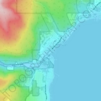
Navn: Topografisk kort Tahoe City, højde, relief.
Gjennomsnittlig høyde: 1 977 m
Minste høyde: 1 893 m
Maksimal høyde: 2 271 m
Gi en donasjon
Andre topografiske kart
Klikk på et kart for å se dets topografi, dets høyde og dets relieff.
Lake Tahoe
United States > California > Placer County
Lake Tahoe has a dry-summer continental climate (Dsb in the Köppen climate classification), featuring warm, dry summers and chilly winters with regular snowfall. Mean annual precipitation ranges from over 55 inches (1,400 mm) for watersheds on the west side of the basin to about 26 inches (660 mm) near the…
Gjennomsnittlig høyde: 2 077 m
Colfax
United States > California > Placer County
Colfax has a hot-summer Mediterranean climate (Köppen Csa) that is characterized by cool, wet winters and hot, dry summers. Summers can be quite hot, especially in the months of July and August where temperatures easily reach 90 °F (32 °C), with plenty of sunshine. Winters, on the other hand, are quite cool…
Gjennomsnittlig høyde: 685 m
Gi en donasjon