
Gi en donasjon
Topografisk kart Grattan
Klikk på kartet for å vise høyde.
Gi en donasjon
Om dette kartet
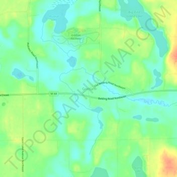
Navn: Topografisk kort Grattan, højde, relief.
Gjennomsnittlig høyde: 261 m
Minste høyde: 244 m
Maksimal høyde: 291 m
Gi en donasjon
Andre topografiske kart
Klikk på et kart for å se dets topografi, dets høyde og dets relieff.
Grand Rapids
United States > Michigan > Kent County
Grand Rapids is situated in a region characterized by relatively flat terrain that gently undulates, influenced by the glacial activity that shaped much of the Midwest. The city itself sits at an elevation of approximately 640 feet (195 meters) above sea level, with the surrounding landscape showcasing low…
Gjennomsnittlig høyde: 216 m
Grand Rapids
United States > Michigan > Kent County
Grand Rapids developed on the banks of the Grand River, where there was once a set of rapids, at an altitude of 610 feet (186 m) above sea level. Ships could navigate on the river up to this fall line, stopping because of the rapids. The river valley is flat and narrow, surrounded by steep hills and bluffs.…
Gjennomsnittlig høyde: 216 m
Gi en donasjon
Gi en donasjon
Echo Lake
United States > Michigan > Kent County > Grand Rapids Charter Township
Gjennomsnittlig høyde: 240 m
Gi en donasjon
Cascade Burton Park
United States > Michigan > Kent County > Grand Rapids
Gjennomsnittlig høyde: 219 m
Plainfield Charter Township
United States > Michigan > Kent County > Belmont
Gjennomsnittlig høyde: 222 m
Gi en donasjon
Gi en donasjon
Gi en donasjon
Gi en donasjon
Gi en donasjon
Comstock Park
United States > Michigan > Kent County > Plainfield Charter Township
Gjennomsnittlig høyde: 206 m
Gi en donasjon
Gi en donasjon