
Takk for at du støtter denne siden ❤️
Gi en donasjon
Gi en donasjon
Topografisk kart Tombstone
Klikk på kartet for å vise høyde.
Takk for at du støtter denne siden ❤️
Gi en donasjon
Gi en donasjon
Tombstone
The Tombstone District located at 31°42′57″N 110°3′53″W / 31.71583°N 110.06472°W / 31.71583; -110.06472 (31.715940, −110.064827) sits atop a mesa (elevation 4,539 feet ) in the San Pedro River valley between the Huachuca Mountains and Whetstone Mountains to the west, and the Mules and the Dragoon Mountains to the east. According to the United States Census Bureau, the city has a total area of 4.3 square miles (11.2 km2), all land.
Takk for at du støtter denne siden ❤️
Gi en donasjon
Gi en donasjon
Om dette kartet
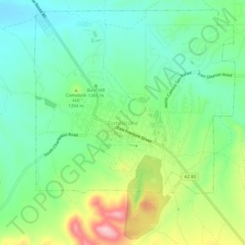
Navn: Topografisk kort Tombstone, højde, relief.
Sted: Tombstone, Cochise County, Arizona, 85638, United States (31.69423 -110.08520 31.73423 -110.04520)
Gjennomsnittlig høyde: 1 373 m
Minste høyde: 1 303 m
Maksimal høyde: 1 517 m
Takk for at du støtter denne siden ❤️
Gi en donasjon
Gi en donasjon