
Gi en donasjon
Topografisk kart Mount Kailash
Klikk på kartet for å vise høyde.
Gi en donasjon
Mount Kailash
Mount Kailash (also Kailasa; Kangrinboqê or Gang Rinpoche; Tibetan: གངས་རིན་པོ་ཆེ; simplified Chinese: 冈仁波齐峰; traditional Chinese: 岡仁波齊峰; Sanskrit: कैलास, IAST: Kailāsa), is a mountain in the Ngari Prefecture, Tibet Autonomous Region of China. It has an altitude of 6,714 m (22,028 ft). It lies in the Kailash Range (Gangdisê Mountains) of the Transhimalaya, in the western part of the Tibetan Plateau. Mount Kailash is less than 100 km towards the north from the western trijunction of the borders of China, India, and Nepal.
Gi en donasjon
Om dette kartet
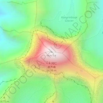
Navn: Topografisk kort Mount Kailash, højde, relief.
Gjennomsnittlig høyde: 5 756 m
Minste høyde: 5 247 m
Maksimal høyde: 6 585 m
Gi en donasjon
Andre topografiske kart
Klikk på et kart for å se dets topografi, dets høyde og dets relieff.