
Gi en donasjon
Topografisk kart Nanchang
Klikk på kartet for å vise høyde.
Gi en donasjon
Om dette kartet
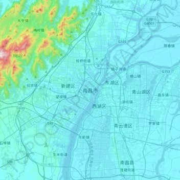
Navn: Topografisk kort Nanchang, højde, relief.
Gjennomsnittlig høyde: 65 m
Minste høyde: 10 m
Maksimal høyde: 815 m
Gi en donasjon
Andre topografiske kart
Klikk på et kart for å se dets topografi, dets høyde og dets relieff.
Jingdezhen
Jingdezhen is situated in the north-east of Jiangxi and borders on Anhui; the city center area is located in the north-east of the Poyang Lake Plain. Its area is 5,256 km2 (2,029 sq mi). The highest point is 1,618 m (5,308 ft), with plains on the southern part having an average altitude of 200 m (660 ft).
Gjennomsnittlig høyde: 167 m
Gi en donasjon
Xingguo County
The length from east to west is 84 kilometers and the width from north to south is 71.5 kilometers. Xingguo is mostly covered by hills and mountains: mountains over 1000 meters on the east, north and west edges, while hilly areas in the center and south parts, with a small basin around the county seat…
Gjennomsnittlig høyde: 321 m
Gi en donasjon
Gi en donasjon
Gi en donasjon
Gi en donasjon
Gi en donasjon
Jingdezhen
Jingdezhen is situated in the north-east of Jiangxi and borders on Anhui; the city center area is located in the north-east of the Poyang Lake Plain. Its area is 5,256 km2 (2,029 sq mi). The highest point is 1,618 m (5,308 ft), with plains on the southern part having an average altitude of 200 m (660 ft).
Gjennomsnittlig høyde: 167 m
Gi en donasjon
Gi en donasjon
Gi en donasjon
Gi en donasjon
Gi en donasjon
Jinggang Mountains Nature Reserve
China > Jiangxi > Jinggangshan City > Ji'an City
The range lies at the junction of four counties - Ninggang, Yongxing, Suichuan and Lingxian. The mountains cover some 670 km2 (260 sq mi), with an average elevation of 381.5 metres (1,252 ft) above sea level. The highest point is 2,120 m (6,960 ft) above sea level.
Gjennomsnittlig høyde: 749 m
Gi en donasjon