
Gi en donasjon
Topografisk kart Phoenix
Klikk på kartet for å vise høyde.
Gi en donasjon
Phoenix
Phoenix is in the south-central portion of Arizona; about halfway between Tucson to the southeast and Flagstaff to the north, in the southwestern United States. By car, the city is approximately 150 miles (240 kilometers) north of the US–Mexico border at Sonoyta and 180 mi (290 km) north of the border at Nogales. The metropolitan area is known as the "Valley of the Sun" due to its location in the Salt River Valley. It lies at a mean elevation of 1,086 feet (331 m), in the northern reaches of the Sonoran Desert.
Gi en donasjon
Om dette kartet
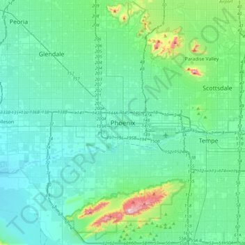
Navn: Topografisk kort Phoenix, højde, relief.
Gjennomsnittlig høyde: 368 m
Minste høyde: 292 m
Maksimal høyde: 813 m
Gi en donasjon
Andre topografiske kart
Klikk på et kart for å se dets topografi, dets høyde og dets relieff.
Cave Creek Park - Thunderbird
United States > Arizona > Maricopa County > Phoenix
Gjennomsnittlig høyde: 401 m
Gi en donasjon
Desert Botanical Garden
United States > Arizona > Maricopa County > Phoenix
Gjennomsnittlig høyde: 389 m