
Gi en donasjon
Topografisk kart Hoye-Crest
Klikk på kartet for å vise høyde.
Gi en donasjon
Hoye-Crest
Hoye-Crest is a summit along Backbone Mountain just inside of Garrett County, Maryland. It is the highest natural point in Maryland at an elevation of 3,360 feet (1,020 m).
Gi en donasjon
Om dette kartet
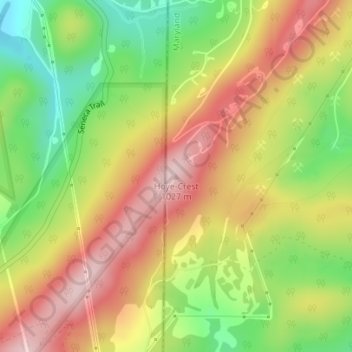
Navn: Topografisk kort Hoye-Crest, højde, relief.
Sted: Hoye-Crest, Garrett County, Maryland, 26716, United States (39.23748 -79.48542 39.23758 -79.48532)
Gjennomsnittlig høyde: 887 m
Minste høyde: 743 m
Maksimal høyde: 1 022 m
Gi en donasjon
Andre topografiske kart
Klikk på et kart for å se dets topografi, dets høyde og dets relieff.
Oakland
United States > Maryland > Garrett County
Oakland, owing to its high elevation and valley location, is among the coldest and snowiest locales in the state of Maryland, and has a warm-summer humid continental climate (Köppen Dfb). The state record low of −40 °F or −40 °C was recorded here on January 13, 1912. The monthly mean temperature ranges…
Gjennomsnittlig høyde: 763 m
Gi en donasjon
Gi en donasjon
Savage River State Forest
United States > Maryland > Garrett County > Grantsville
Gjennomsnittlig høyde: 738 m