
Gi en donasjon
Topografisk kart Wallacestone
Klikk på kartet for å vise høyde.
Gi en donasjon
Om dette kartet
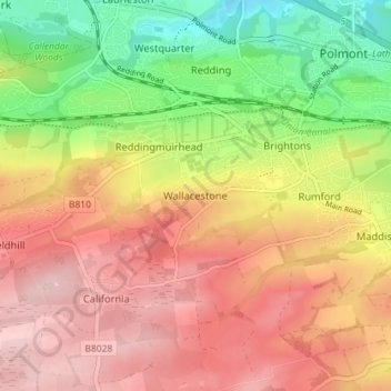
Navn: Topografisk kort Wallacestone, højde, relief.
Sted: Wallacestone, Falkirk, Scotland, FK2 0DJ, United Kingdom (55.95603 -3.75460 55.99603 -3.71460)
Gjennomsnittlig høyde: 119 m
Minste høyde: 10 m
Maksimal høyde: 206 m
Gi en donasjon
Andre topografiske kart
Klikk på et kart for å se dets topografi, dets høyde og dets relieff.
Falkirk
United Kingdom > Scotland > Falkirk
Falkirk is located in an area of undulating topography between the Slamannan Plateau and the upper reaches of the Firth of Forth. The area to the north of Falkirk is part of the floodplain of the River Carron. Two tributaries of the River Carron - the East Burn and the West Burn flow through the town and form…
Gjennomsnittlig høyde: 42 m
Gi en donasjon
Gi en donasjon
Union Canal
United Kingdom > Scotland > Falkirk
Canal commences from the sixteenth lock of the Forth and Clyde Navigation, about two miles west of Falkirk, in the county of Sterling , whence it takes an eastwardly course on the south side of the above-mentioned town, by some collieries; thence, through Black Hill Tunnel, and across the Glen Water, on which…
Gjennomsnittlig høyde: 136 m