
Gi en donasjon
Topografisk kart Minnis Bay
Klikk på kartet for å vise høyde.
Gi en donasjon
Om dette kartet
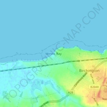
Navn: Topografisk kort Minnis Bay, højde, relief.
Sted: Minnis Bay, Thanet, Kent, England, CT7 9QR, United Kingdom (51.36020 1.26560 51.40020 1.30560)
Gjennomsnittlig høyde: 6 m
Minste høyde: -1 m
Maksimal høyde: 36 m
Gi en donasjon
Andre topografiske kart
Klikk på et kart for å se dets topografi, dets høyde og dets relieff.
Ramsgate
United Kingdom > England > Kent > Thanet
In 2017 Ramsgate was chosen as one of the first ten Heritage Action Zones (HAZ) by Historic England, with the aim of stimulating economic growth by taking advantage of Ramsgate's historic environment. Part of this project included a Historic Landscape Characterisation Study which assessed and mapped the…
Gjennomsnittlig høyde: 25 m
Gi en donasjon
Gi en donasjon
Ramsgate
United Kingdom > England > Kent > Thanet
In 2017 Ramsgate was chosen as one of the first ten Heritage Action Zones (HAZ) by Historic England, with the aim of stimulating economic growth using Ramsgate's historic environment as a catalyst. Part of this project included a Historic Landscape Characterisation Study which assessed and mapped the patterns…
Gjennomsnittlig høyde: 25 m