
Gi en donasjon
Topografisk kart Clarksville
Klikk på kartet for å vise høyde.
Gi en donasjon
Om dette kartet
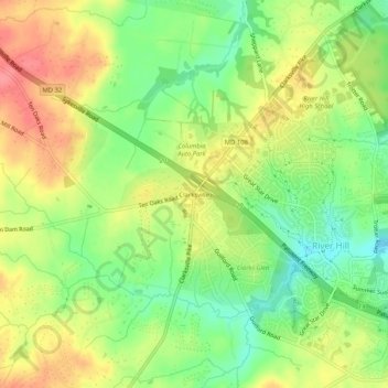
Navn: Topografisk kort Clarksville, højde, relief.
Gjennomsnittlig høyde: 134 m
Minste høyde: 96 m
Maksimal høyde: 173 m
Gi en donasjon
Andre topografiske kart
Klikk på et kart for å se dets topografi, dets høyde og dets relieff.
Columbia
United States > Maryland > Howard County > Columbia
The primary landforms in Columbia are rolling hills and stream valleys; Columbia's road network is laid out to follow the terrain, with many winding streets and cul-de-sacs. Elevations range from about 200 to 500 feet (61 to 152 m) above sea level. Most of Columbia is drained by the Middle Patuxent and Little…
Gjennomsnittlig høyde: 113 m
Columbia
United States > Maryland > Howard County > Columbia
The primary landforms in Columbia are rolling hills and stream valleys; Columbia's road network is laid out to follow the terrain, with many winding streets and cul-de-sacs. Elevations range from about 200 to 500 feet (61 to 152 m) above sea level. Most of Columbia is drained by the Middle Patuxent and Little…
Gjennomsnittlig høyde: 114 m
Howard County Conservancy at Mt. Pleasant
United States > Maryland > Howard County > Columbia
Gjennomsnittlig høyde: 135 m
Gi en donasjon