
Takk for at du støtter denne siden ❤️
Gi en donasjon
Gi en donasjon
Topografisk kart Kirandul
Klikk på kartet for å vise høyde.
Takk for at du støtter denne siden ❤️
Gi en donasjon
Gi en donasjon
Kirandul
The Kothavalasa–Kirandul line of East Coast Railway from Kirandul to Visakhapatnam via Koraput is laid through the Eastern Ghats. Up to Araku station, it has many tunnels. Also it pass through the highest elevation Broad gauge station in the Eastern ghats, Semiliguda, just before the Borra caves. Kirandul - Kottavalasa Railroad is the record high Broad Gauge line in the Eastern Ghats. The KK Line has the distinction of being the second highest broad gauge railway line in the country after the one in Jammu.
Takk for at du støtter denne siden ❤️
Gi en donasjon
Gi en donasjon
Om dette kartet
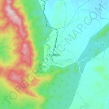
Navn: Topografisk kort Kirandul, højde, relief.
Gjennomsnittlig høyde: 742 m
Minste høyde: 541 m
Maksimal høyde: 1 270 m
Takk for at du støtter denne siden ❤️
Gi en donasjon
Gi en donasjon