
Gi en donasjon
Topografisk kart Moreland
Klikk på kartet for å vise høyde.
Gi en donasjon
Om dette kartet
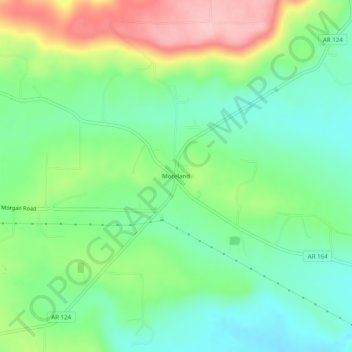
Navn: Topografisk kort Moreland, højde, relief.
Sted: Moreland, Pope County, Arkansas, United States (35.34758 -93.01850 35.38758 -92.97850)
Gjennomsnittlig høyde: 236 m
Minste høyde: 174 m
Maksimal høyde: 349 m
Gi en donasjon
Andre topografiske kart
Klikk på et kart for å se dets topografi, dets høyde og dets relieff.
Gi en donasjon
Dover
United States > Arkansas > Pope County
The mild hills historically supported oak-hickory forest or oak-hickory-pine forest. Elevation changes and soil types make the Arkansas Valley Hills largely unsuitable for row agriculture. Instead, forest has been cleared for pastureland, poultry farming or ranching. Logging remains an important land use where…
Gjennomsnittlig høyde: 164 m
Gi en donasjon