
Gi en donasjon
Topografisk kart Rockvale
Klikk på kartet for å vise høyde.
Gi en donasjon
Om dette kartet
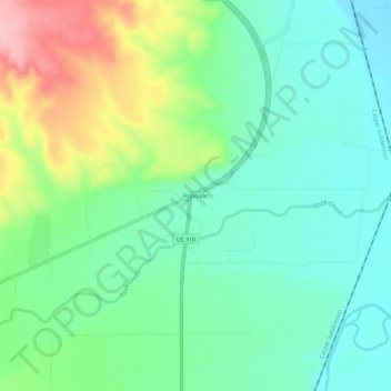
Navn: Topografisk kort Rockvale, højde, relief.
Sted: Rockvale, Carbon County, Montana, United States (45.50233 -108.88115 45.54233 -108.84115)
Gjennomsnittlig høyde: 1 077 m
Minste høyde: 1 033 m
Maksimal høyde: 1 174 m
Gi en donasjon
Andre topografiske kart
Klikk på et kart for å se dets topografi, dets høyde og dets relieff.
Red Lodge
United States > Montana > Carbon County
Red Lodge experiences a continental climate (Köppen Dfb) with cold, somewhat dry winters and warm, wetter summers. Summers are cooler than in areas of Montana further north, due to the high elevation. Winters however, are milder than areas further to the east due to the chinook wind influence, as with most of…
Gjennomsnittlig høyde: 1 720 m
Gi en donasjon