
Gi en donasjon
Topografisk kart Cora
Klikk på kartet for å vise høyde.
Gi en donasjon
Om dette kartet
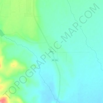
Navn: Topografisk kort Cora, højde, relief.
Sted: Cora, Sublette County, Wyoming, United States (42.91966 -109.99960 42.95966 -109.95960)
Gjennomsnittlig høyde: 2 242 m
Minste høyde: 2 217 m
Maksimal høyde: 2 331 m
Gi en donasjon
Andre topografiske kart
Klikk på et kart for å se dets topografi, dets høyde og dets relieff.
Pinedale
United States > Wyoming > Sublette County
Pinedale is located at 42°51′58″N 109°51′53″W / 42.86611°N 109.86472°W / 42.86611; -109.86472 (42.866162, −109.864622) and sits at an elevation of 7,175 feet above sea level. According to the United States Census Bureau, the town has a total area of 2.15 square miles (5.57 km2), all land.
Gjennomsnittlig høyde: 2 196 m
Gi en donasjon
Pinedale
United States > Wyoming > Sublette County
Pinedale is located at 42°51′58″N 109°51′53″W / 42.86611°N 109.86472°W / 42.86611; -109.86472 (42.866162, −109.864622)[8] and sits at an elevation of 7,175 feet above sea level. According to the United States Census Bureau, the town has a total area of 2.15 square miles (5.57 km2), all land.[9]
Gjennomsnittlig høyde: 2 196 m