
Takk for at du støtter denne siden ❤️
Gi en donasjon
Gi en donasjon
Topografisk kart Williams
Klikk på kartet for å vise høyde.
Takk for at du støtter denne siden ❤️
Gi en donasjon
Gi en donasjon
Om dette kartet
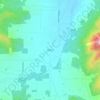
Navn: Topografisk kort Williams, højde, relief.
Sted: Williams, Josephine County, Oregon, 97544, United States (42.19868 -123.29396 42.23868 -123.25396)
Gjennomsnittlig høyde: 484 m
Minste høyde: 401 m
Maksimal høyde: 874 m
Takk for at du støtter denne siden ❤️
Gi en donasjon
Gi en donasjon
Andre topografiske kart
Klikk på et kart for å se dets topografi, dets høyde og dets relieff.
Cave Junction
United States > Oregon > Josephine County
Cave Junction is located on U.S. Route 199 at its junction with Oregon Route 46. It is about 30 miles or 48 kilometres southwest of Grants Pass, Oregon, and 53 miles or 85 kilometres northeast of Crescent City, California. The city lies in the Illinois Valley, on the northwest slope of the Siskiyou Range, at…
Gjennomsnittlig høyde: 411 m
Takk for at du støtter denne siden ❤️
Gi en donasjon
Gi en donasjon