
Takk for at du støtter denne siden ❤️
Gi en donasjon
Gi en donasjon
Topografisk kart Wing
Klikk på kartet for å vise høyde.
Takk for at du støtter denne siden ❤️
Gi en donasjon
Gi en donasjon
Om dette kartet
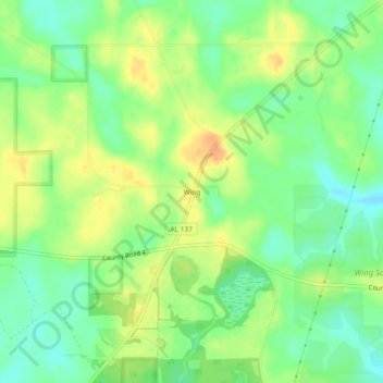
Navn: Topografisk kort Wing, højde, relief.
Sted: Wing, Covington County, Alabama, United States (31.00768 -86.63051 31.04768 -86.59051)
Gjennomsnittlig høyde: 73 m
Minste høyde: 55 m
Maksimal høyde: 92 m
Takk for at du støtter denne siden ❤️
Gi en donasjon
Gi en donasjon
Andre topografiske kart
Klikk på et kart for å se dets topografi, dets høyde og dets relieff.
Conecuh National Forest
United States > Alabama > Covington County
The Conecuh National Forest in southern Alabama covers 83,000 acres (340 km2), along the Alabama - Florida line in Covington and Escambia counties. Topography is level to moderately sloping, broad ridges with stream terraces and broad floodplains.
Gjennomsnittlig høyde: 75 m
Takk for at du støtter denne siden ❤️
Gi en donasjon
Gi en donasjon