
Gi en donasjon
Topografisk kart Austin
Klikk på kartet for å vise høyde.
Gi en donasjon
Om dette kartet
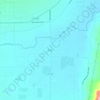
Navn: Topografisk kort Austin, højde, relief.
Sted: Austin, Sevier County, Utah, 84724, United States (38.65219 -112.14159 38.69219 -112.10159)
Gjennomsnittlig høyde: 1 624 m
Minste høyde: 1 610 m
Maksimal høyde: 1 772 m
Gi en donasjon
Andre topografiske kart
Klikk på et kart for å se dets topografi, dets høyde og dets relieff.
Fish Lake
United States > Utah > Sevier County
Fish Lake is a high alpine lake (elevation approximately 8,848 ft or 2,700 m) located in the Fishlake/ Southern Wasatch Plateau region of south-central Utah, United States. It lies within and is the namesake of the Fishlake National Forest.
Gjennomsnittlig høyde: 2 886 m
Richfield
United States > Utah > Sevier County
Richfield experiences a cold semi-arid climate (Köppen BSk) with four distinct seasons. Winter high temperatures average in the 30s and 40s with many milder days; low temperatures average in the teens and twenties, with a few mornings starting near or below zero. Snowfall is common, but usually melts in a day…
Gjennomsnittlig høyde: 1 659 m
Gi en donasjon
Richfield
United States > Utah > Sevier County
Richfield experiences a cold semi-arid climate (Köppen BSk) with four distinct seasons. Winter high temperatures average in the 30s and 40s with many milder days; low temperatures average in the teens and twenties, with a few mornings starting near or below zero. Snowfall is common, but usually melts in a day…
Gjennomsnittlig høyde: 1 659 m