
Gi en donasjon
Topografisk kart Lindbergh
Klikk på kartet for å vise høyde.
Gi en donasjon
Om dette kartet
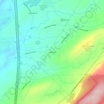
Navn: Topografisk kort Lindbergh, højde, relief.
Gjennomsnittlig høyde: 386 m
Minste høyde: 312 m
Maksimal høyde: 566 m
Gi en donasjon
Andre topografiske kart
Klikk på et kart for å se dets topografi, dets høyde og dets relieff.
Mountain Top
United States > Pennsylvania > Luzerne County > Wright Township
The elevation within the Mountain Top CDP ranges from 1,070 feet (330 m) above sea level along Big Wapwallopen Creek in the southwest, to 1,860 feet (570 m) atop Nescopeck Mountain southwest of Rita, to 1,871 feet (570 m) at the east end of Penobscot Mountain in the north of the CDP. The central village of…
Gjennomsnittlig høyde: 463 m
Mountain Top
United States > Pennsylvania > Luzerne County > Wright Township
The elevation in Mountain Top ranges from 1,070 feet (330 m) above sea level along Big Wapwallopen Creek in the southwest, to 1,860 feet (570 m) atop Nescopeck Mountain southwest of Rita, to 1,871 feet (570 m) at the east end of Penobscot Mountain in north Mountain Top. The central village of Mountain Top sits…
Gjennomsnittlig høyde: 463 m
Mountain Top
United States > Pennsylvania > Luzerne County > Wright Township
The elevation within the Mountain Top CDP ranges from 1,070 feet (330 m) above sea level along Big Wapwallopen Creek in the southwest, to 1,860 feet (570 m) atop Nescopeck Mountain southwest of Rita, to 1,871 feet (570 m) at the east end of Penobscot Mountain in the north of the CDP. The central village of…
Gjennomsnittlig høyde: 463 m