
Gi en donasjon
Topografisk kart Freedom
Klikk på kartet for å vise høyde.
Gi en donasjon
Om dette kartet
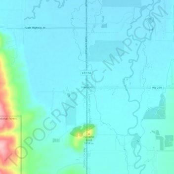
Navn: Topografisk kort Freedom, højde, relief.
Sted: Freedom, Lincoln County, Wyoming, 83120, United States (42.96266 -111.06390 43.00266 -111.02390)
Gjennomsnittlig høyde: 1 774 m
Minste høyde: 1 751 m
Maksimal høyde: 1 926 m
Gi en donasjon
Andre topografiske kart
Klikk på et kart for å se dets topografi, dets høyde og dets relieff.
Thayne
United States > Wyoming > Lincoln County
Thayne is located at 42°55′11″N 111°0′3″W / 42.91972°N 111.00083°W / 42.91972; -111.00083 (42.919754, –111.000714), at 5906 feet in elevation. It sits in the northern portion of Wyoming's grassy Star Valley, close to the Salt River. Thayne is surrounded by green grassland and ranches,…
Gjennomsnittlig høyde: 1 814 m
Gi en donasjon
Gi en donasjon
Thayne
United States > Wyoming > Lincoln County
Thayne is located at 42°55′11″N 111°0′3″W / 42.91972°N 111.00083°W / 42.91972; -111.00083 (42.919754, –111.000714), at 5906 feet in elevation. It sits in the northern portion of Wyoming's grassy Star Valley, close to the Salt River. Thayne is surrounded by green grassland and ranches,…
Gjennomsnittlig høyde: 1 814 m
Gi en donasjon