
Takk for at du støtter denne siden ❤️
Gi en donasjon
Gi en donasjon
Topografisk kart Lenox
Klikk på kartet for å vise høyde.
Takk for at du støtter denne siden ❤️
Gi en donasjon
Gi en donasjon
Om dette kartet
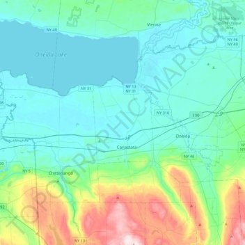
Navn: Topografisk kort Lenox, højde, relief.
Sted: Lenox, Madison County, New York, 13032, United States (42.95128 -75.91818 43.27128 -75.59818)
Gjennomsnittlig høyde: 195 m
Minste høyde: 110 m
Maksimal høyde: 564 m
Takk for at du støtter denne siden ❤️
Gi en donasjon
Gi en donasjon
Andre topografiske kart
Klikk på et kart for å se dets topografi, dets høyde og dets relieff.
Takk for at du støtter denne siden ❤️
Gi en donasjon
Gi en donasjon
Village of Hamilton
United States > New York > Madison County
Northeast of Hamilton is Payne Brook, which starts at Lake Moraine and travels through the village before converging with the Chenango River. The elevation of the village's municipal airport (Hamilton Municipal Airport) is approximately 1,100 feet (340 m) above sea level.
Gjennomsnittlig høyde: 386 m
Takk for at du støtter denne siden ❤️
Gi en donasjon
Gi en donasjon