
Takk for at du støtter denne siden ❤️
Gi en donasjon
Gi en donasjon
Topografisk kart Lawrenceburg
Klikk på kartet for å vise høyde.
Takk for at du støtter denne siden ❤️
Gi en donasjon
Gi en donasjon
Lawrenceburg
The city of Lawrenceburg has a total area of 12.6 square miles (33 km2). It is the largest city on the state line between Chattanooga and Memphis. Located on the southern Highland Rim, Lawrence County and Lawrenceburg are set atop of a large mountain plateau of the Appalachian Mountain range with elevations ranging between 810 feet (250 m) to over 1,120 feet (340 m). Map of the Appalachian Mountain Range.
Takk for at du støtter denne siden ❤️
Gi en donasjon
Gi en donasjon
Om dette kartet
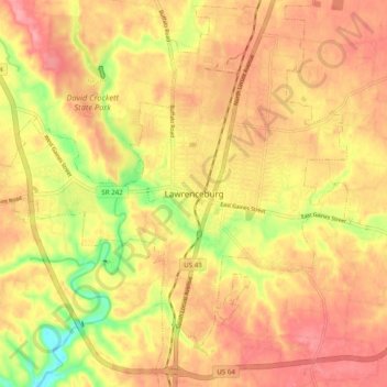
Navn: Topografisk kort Lawrenceburg, højde, relief.
Gjennomsnittlig høyde: 278 m
Minste høyde: 213 m
Maksimal høyde: 317 m
Takk for at du støtter denne siden ❤️
Gi en donasjon
Gi en donasjon