
Gi en donasjon
Topografisk kart Briggs
Klikk på kartet for å vise høyde.
Gi en donasjon
Briggs
Briggs lies along U.S. Route 183 and FM 2657, northeast of Burnet. Its elevation is 1,102 feet (336 m), and it is located at 30°53′23″N 97°55′30″W / 30.88972°N 97.92500°W / 30.88972; -97.92500. Although Briggs is unincorporated, it has a post office, with the ZIP code of 78608. The population was 101 at the 2020 census.
Gi en donasjon
Om dette kartet
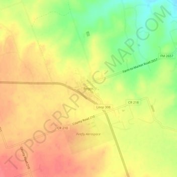
Navn: Topografisk kort Briggs, højde, relief.
Sted: Briggs, Burnet County, Texas, 78608, United States (30.86877 -97.94581 30.90877 -97.90581)
Gjennomsnittlig høyde: 336 m
Minste høyde: 295 m
Maksimal høyde: 362 m
Gi en donasjon
Andre topografiske kart
Klikk på et kart for å se dets topografi, dets høyde og dets relieff.
Gi en donasjon
Inks Lake State Park
United States > Texas > Burnet County > Burnet
Conservation Pool Elevation usually stays around 888.22 ft. msl; however, this lake does fluctuate about 1 foot annually. Inks lake water clarity can be seen as clear to slightly stained mostly throughout the year. It tends to have higher turbidity during the rainy season due to excessive amounts of runoff.
Gjennomsnittlig høyde: 294 m
Gi en donasjon