
Takk for at du støtter denne siden ❤️
Gi en donasjon
Gi en donasjon
Topografisk kart Dolomite
Klikk på kartet for å vise høyde.
Takk for at du støtter denne siden ❤️
Gi en donasjon
Gi en donasjon
Om dette kartet
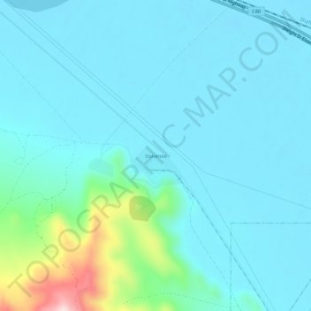
Navn: Topografisk kort Dolomite, højde, relief.
Sted: Dolomite, Tooele County, Utah, United States (40.68313 -112.59586 40.72313 -112.55586)
Gjennomsnittlig høyde: 1 324 m
Minste høyde: 1 278 m
Maksimal høyde: 1 598 m
Takk for at du støtter denne siden ❤️
Gi en donasjon
Gi en donasjon
Andre topografiske kart
Klikk på et kart for å se dets topografi, dets høyde og dets relieff.
Lake Point
United States > Utah > Tooele County
John C. Frémont, a second lieutenant in the U.S. Army Corps of Topographical Engineers, was commissioned by the US Government to explore the Mexican territory west of the Louisiana Purchase with a special interest in the terrain and various routes that could link the Midwest to California. In the summer of…
Gjennomsnittlig høyde: 1 425 m
Takk for at du støtter denne siden ❤️
Gi en donasjon
Gi en donasjon