Geolokaliser

Topografisk kart Mableton

Klikk på kartet for å vise høyde.

Om dette kartet

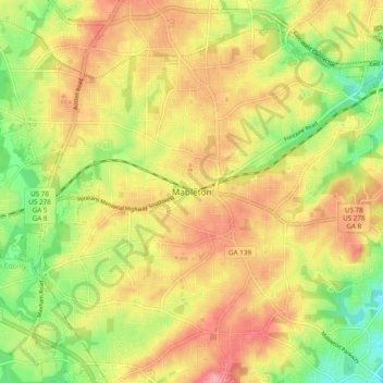
Navn: Topografisk kort Mableton, højde, relief.

Sted: Mableton, Cobb County, Georgia, 30168, United States (33.77883 -84.62226 33.85883 -84.54226)

Gjennomsnittlig høyde: 298 m

Minste høyde: 234 m

Maksimal høyde: 356 m

Andre topografiske kart

Klikk på et kart for å se dets topografi, dets høyde og dets relieff.

Marietta

United States > Georgia > Cobb County

Gjennomsnittlig høyde: 323 m

Mableton

United States > Georgia > Cobb County

Gjennomsnittlig høyde: 287 m

Acworth

United States > Georgia > Cobb County

Gjennomsnittlig høyde: 281 m

Kennesaw

United States > Georgia > Cobb County

Kennesaw is located in northwestern Cobb County, bordered by the city of Acworth to the northwest. Kennesaw Mountain is located southeast of the city limits in the battlefield park. Its summit is the highest point in the Atlanta metro area, at an elevation of 1,808 feet (551 m) above sea level. The city was…

Gjennomsnittlig høyde: 317 m

Smyrna

United States > Georgia > Cobb County

Gjennomsnittlig høyde: 289 m

Lake Acworth

United States > Georgia > Cobb County > Acworth

Gjennomsnittlig høyde: 273 m

Marietta

United States > Georgia > Cobb County

Gjennomsnittlig høyde: 323 m

Marietta

United States > Georgia > Cobb County

Gjennomsnittlig høyde: 323 m

Vinings

United States > Georgia > Cobb County > Vinings

Gjennomsnittlig høyde: 278 m

Austell

United States > Georgia > Cobb County

Gjennomsnittlig høyde: 289 m

Smyrna

United States > Georgia > Cobb County

Gjennomsnittlig høyde: 289 m

Powder Springs

United States > Georgia > Cobb County

Gjennomsnittlig høyde: 291 m

Marietta

United States > Georgia > Cobb County

Gjennomsnittlig høyde: 323 m

Mableton

United States > Georgia > Cobb County

Gjennomsnittlig høyde: 287 m

Acworth

United States > Georgia > Cobb County

Gjennomsnittlig høyde: 281 m

Marietta

United States > Georgia > Cobb County

Gjennomsnittlig høyde: 323 m

Aboretum

United States > Georgia > Cobb County

Gjennomsnittlig høyde: 319 m

Kennesaw

United States > Georgia > Cobb County

Kennesaw is located in northwestern Cobb County, bordered by the city of Acworth to the northwest. Kennesaw Mountain is located southeast of the city limits in the battlefield park. Its summit is the highest point in the Atlanta metro area, at an elevation of 1,808 feet (551 m) above sea level. The city was…

Gjennomsnittlig høyde: 317 m

Powder Springs

United States > Georgia > Cobb County

Gjennomsnittlig høyde: 291 m