
Gi en donasjon
Topografisk kart Shafter
Klikk på kartet for å vise høyde.
Gi en donasjon
Om dette kartet
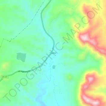
Navn: Topografisk kort Shafter, højde, relief.
Sted: Shafter, Presidio County, Texas, United States (29.79736 -104.32613 29.83736 -104.28613)
Gjennomsnittlig høyde: 1 256 m
Minste høyde: 1 131 m
Maksimal høyde: 1 524 m
Gi en donasjon
Andre topografiske kart
Klikk på et kart for å se dets topografi, dets høyde og dets relieff.
Marfa
United States > Texas > Presidio County
Marfa experiences a semi-arid climate (BSk) with hot summers and cool winters. Due to its elevation and aridity, the diurnal temperature variation is substantial.
Gjennomsnittlig høyde: 1 434 m
Chinati Mountains State Natural Area
United States > Texas > Presidio County
Gjennomsnittlig høyde: 1 241 m
Marfa
United States > Texas > Presidio County
Marfa experiences a semi-arid climate (BSk) with hot summers and cool winters. Due to its elevation and aridity, the diurnal temperature variation is substantial.
Gjennomsnittlig høyde: 1 434 m
Gi en donasjon