
Gi en donasjon
Topografisk kart Jenson
Klikk på kartet for å vise høyde.
Gi en donasjon
Om dette kartet
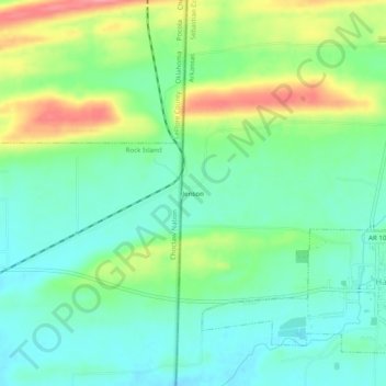
Navn: Topografisk kort Jenson, højde, relief.
Sted: Jenson, Sebastian County, Arkansas, United States (35.17671 -94.45706 35.21671 -94.41706)
Gjennomsnittlig høyde: 177 m
Minste høyde: 146 m
Maksimal høyde: 240 m
Gi en donasjon
Andre topografiske kart
Klikk på et kart for å se dets topografi, dets høyde og dets relieff.
Fort Smith
United States > Arkansas > Sebastian County
The United States acquired this territory and large areas west of the Mississippi River from France in the Louisiana Purchase (1803). Soon after, the government sent the Pike Expedition (1806) to explore the areas along the Arkansas River. The US founded Fort Smith in 1817 as a military post. It was named…
Gjennomsnittlig høyde: 140 m
Fort Smith
United States > Arkansas > Sebastian County
The United States acquired the territory and large areas west of the Mississippi River from France in the Louisiana Purchase (1803). Soon after, the government sent the Pike Expedition (1806) to explore the areas along the Arkansas River. The US founded Fort Smith in 1817 as a military post. It was named after…
Gjennomsnittlig høyde: 140 m
Gi en donasjon