
Takk for at du støtter denne siden ❤️
Gi en donasjon
Gi en donasjon
Topografisk kart Nimo
Klikk på kartet for å vise høyde.
Takk for at du støtter denne siden ❤️
Gi en donasjon
Gi en donasjon
Om dette kartet
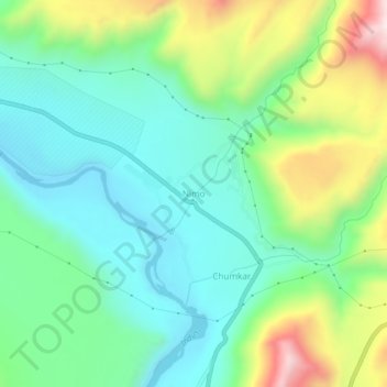
Navn: Topografisk kort Nimo, højde, relief.
Sted: Nimo, Leh Tehsil, Leh district, Ladakh, India (34.17632 77.31551 34.21632 77.35551)
Gjennomsnittlig høyde: 3 282 m
Minste høyde: 3 089 m
Maksimal høyde: 3 731 m
Takk for at du støtter denne siden ❤️
Gi en donasjon
Gi en donasjon
Andre topografiske kart
Klikk på et kart for å se dets topografi, dets høyde og dets relieff.
Indus
India > Ladakh > Leh Tehsil
In the uppermost, highest part of the Indus River basin there are relatively few genera and species: Diptychus, Ptychobarbus, Schizopyge, Schizopygopsis and Schizothorax snowtrout, Triplophysa loaches, and the catfish Glyptosternon reticulatum. Going downstream these are soon joined by the golden mahseer Tor…
Gjennomsnittlig høyde: 4 192 m