
Gi en donasjon
Topografisk kart Altonville
Klikk på kartet for å vise høyde.
Gi en donasjon
Om dette kartet
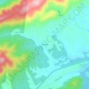
Navn: Topografisk kort Altonville, højde, relief.
Gjennomsnittlig høyde: 402 m
Minste høyde: 318 m
Maksimal høyde: 630 m
Gi en donasjon
Andre topografiske kart
Klikk på et kart for å se dets topografi, dets høyde og dets relieff.
Rogersville
United States > Tennessee > Hawkins County
Rogersville is located slightly southwest of the center of Hawkins County. According to the United States Census Bureau, the town has a total area of 3.4 square miles (8.8 km2), all land. The town is in the valley of Crockett Creek, a southwest-flowing tributary of the Holston River. The elevation of…
Gjennomsnittlig høyde: 416 m
Gi en donasjon
Rogersville
United States > Tennessee > Hawkins County
Rogersville is located slightly southwest of the center of Hawkins County. According to the United States Census Bureau, the town has a total area of 3.4 square miles (8.8 km2), all land. The town is in the valley of Crockett Creek, a southwest-flowing tributary of the Holston River. The elevation of…
Gjennomsnittlig høyde: 416 m