
Takk for at du støtter denne siden ❤️
Gi en donasjon
Gi en donasjon
Topografisk kart Huangcaoling
Klikk på kartet for å vise høyde.
Takk for at du støtter denne siden ❤️
Gi en donasjon
Gi en donasjon
Om dette kartet
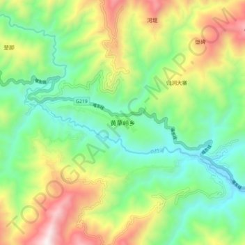
Navn: Topografisk kort Huangcaoling, højde, relief.
Sted: Huangcaoling, Yuanyang County, Honghe, Yunnan, China (22.88800 102.62600 22.96800 102.70600)
Gjennomsnittlig høyde: 1 057 m
Minste høyde: 571 m
Maksimal høyde: 1 922 m
Takk for at du støtter denne siden ❤️
Gi en donasjon
Gi en donasjon
Andre topografiske kart
Klikk på et kart for å se dets topografi, dets høyde og dets relieff.
Honghe Hani Rice Terraces
China > Yunnan > Yuanyang County > Zhulu
The terraces follow a distinct vertical structure that has allowed the landscape to persist for so long, incorporating forests, villages, terraces, and water supply. At the tops of the mountains (above 2000 meters in elevation), the forests are conserved, to act as a catchment for the rainfall and to…
Gjennomsnittlig høyde: 1 585 m