
Gi en donasjon
Topografisk kart Mount Bullion
Klikk på kartet for å vise høyde.
Gi en donasjon
Om dette kartet
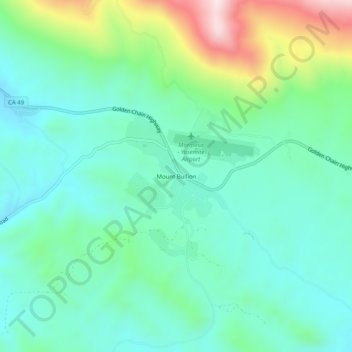
Navn: Topografisk kort Mount Bullion, højde, relief.
Sted: Mount Bullion, Mariposa County, California, United States (37.48716 -120.06490 37.52716 -120.02490)
Gjennomsnittlig høyde: 714 m
Minste høyde: 580 m
Maksimal høyde: 1 105 m
Gi en donasjon
Andre topografiske kart
Klikk på et kart for å se dets topografi, dets høyde og dets relieff.
Yosemite Valley
United States > California > Mariposa County > Yosemite Village
Gjennomsnittlig høyde: 2 016 m
Echo Valley
United States > California > Mariposa County
Echo Valley is a valley in Yosemite National Park, at an elevation of 7,021 feet (2,140 m). It is located along Echo Creek, about 3 miles (5 km) west of Merced Lake, at 37°44′38″N 119°26′03″W / 37.7438°N 119.4343°W / 37.7438; -119.4343. It is bounded on the south by the Merced River.
Gjennomsnittlig høyde: 2 333 m
Gi en donasjon
Yosemite Valley
United States > California > Mariposa County > Yosemite Village
Gjennomsnittlig høyde: 2 012 m
Yosemite Valley
United States > California > Mariposa County > Yosemite Village
Gjennomsnittlig høyde: 2 016 m