
Gi en donasjon
Topografisk kart Trail
Klikk på kartet for å vise høyde.
Gi en donasjon
Om dette kartet
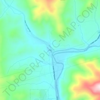
Navn: Topografisk kort Trail, højde, relief.
Sted: Trail, Jackson County, Oregon, 97539, United States (42.62846 -122.83060 42.66846 -122.79060)
Gjennomsnittlig høyde: 534 m
Minste høyde: 423 m
Maksimal høyde: 873 m
Gi en donasjon
Andre topografiske kart
Klikk på et kart for å se dets topografi, dets høyde og dets relieff.
Ashland
United States > Oregon > Jackson County
Ashland lies within Oregon's southwest interior climate zone, in which all but the higher-elevation sites are in the rain shadow of the Oregon Coast Range to the west. The largest urban areas in this zone in addition to Ashland are Medford and Grants Pass in the Rogue Valley, and Roseburg in the Umpqua River…
Gjennomsnittlig høyde: 774 m
Gi en donasjon
Gi en donasjon
Gi en donasjon
Ashland
United States > Oregon > Jackson County
Ashland lies within Oregon's southwest interior climate zone, in which all but the higher-elevation sites are in the rain shadow of the Oregon Coast Range to the west. The largest urban areas in this zone in addition to Ashland are Medford and Grants Pass in the Rogue Valley, and Roseburg in the Umpqua River…
Gjennomsnittlig høyde: 774 m
Gi en donasjon