
Gi en donasjon
Topografisk kart McDonalds
Klikk på kartet for å vise høyde.
Gi en donasjon
Om dette kartet
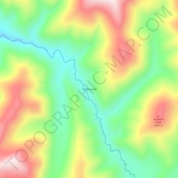
Navn: Topografisk kort McDonalds, højde, relief.
Sted: McDonalds, Shoshone County, Idaho, United States (47.01436 -115.17236 47.05436 -115.13236)
Gjennomsnittlig høyde: 1 692 m
Minste høyde: 1 473 m
Maksimal høyde: 1 971 m
Gi en donasjon
Andre topografiske kart
Klikk på et kart for å se dets topografi, dets høyde og dets relieff.
Wardner
United States > Idaho > Shoshone County
Wardner is located at 47°31′23″N 116°8′3″W / 47.52306°N 116.13417°W / 47.52306; -116.13417 (47.523164, -116.134190), at an elevation of 2,657 feet (810 m) above sea level.
Gjennomsnittlig høyde: 1 186 m
Kellogg
United States > Idaho > Shoshone County
Kellogg is located at 47°32′18″N 116°07′31″W / 47.53833°N 116.12528°W / 47.53833; -116.12528 (47.538391, -116.125406), at an elevation of 2,303 feet (702 m) above sea level.
Gjennomsnittlig høyde: 939 m
Mullan
United States > Idaho > Shoshone County
In Shoshone County at the east end of the Silver Valley, Mullan is in a sheltered canyon of the Coeur d'Alene Mountains at an elevation of 3,278 feet (1,000 m) above sea level. The entrance to the Lucky Friday mine is several hundred yards east of the city center; the active mine (silver, lead, & zinc)…
Gjennomsnittlig høyde: 1 168 m
Gi en donasjon
Mullan
United States > Idaho > Shoshone County
In Shoshone County at the east end of the Silver Valley, Mullan is in a sheltered canyon of the Coeur d'Alene Mountains at an elevation of 3,278 feet (1,000 m) above sea level. The entrance to the Lucky Friday mine is several hundred yards east of the city center; the active mine (silver, lead, & zinc)…
Gjennomsnittlig høyde: 1 168 m
Kellogg
United States > Idaho > Shoshone County
Kellogg is located at 47°32′18″N 116°07′31″W / 47.53833°N 116.12528°W / 47.53833; -116.12528 (47.538391, -116.125406), at an elevation of 2,303 feet (702 m) above sea level.
Gjennomsnittlig høyde: 939 m
Gi en donasjon