
Gi en donasjon
Topografisk kart Hopa
Klikk på kartet for å vise høyde.
Gi en donasjon
Om dette kartet
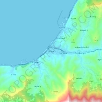
Navn: Topografisk kort Hopa, højde, relief.
Sted: Hopa, Artvin, Black Sea Region, 08600, Turkey (41.34875 41.37816 41.42875 41.45816)
Gjennomsnittlig høyde: 168 m
Minste høyde: 0 m
Maksimal høyde: 1 060 m
Gi en donasjon
Andre topografiske kart
Klikk på et kart for å se dets topografi, dets høyde og dets relieff.
Gi en donasjon
Kaş
As the tenth largest district of Antalya as of 2021, Kaş is on a hill running down to the Turquoise Coast of southwestern Turkey. The district has a typical Mediterranean climate of hot, dry summers and mild, wet winters, which allows the growth of oranges, lemons and bananas. The lowland areas are also…
Gjennomsnittlig høyde: 837 m
Antalya
The highest point of the Taurus mountains is Akdağ at an altitude of 3025 metres. Located to the northwest of the city centre and at a distance of 50 km (31 mi) is the Saklıkent ski and recreation centre on Beydağları. Here one can ski and then go down to the shore and into the sea during the months of…
Gjennomsnittlig høyde: 644 m
Gi en donasjon
Gi en donasjon
Anatolia
Anatolia (Turkish: Anadolu), also known as Asia Minor, is a peninsula in West Asia that makes up the majority of the land area of Turkey. It is the westernmost protrusion of Asia and is geographically bounded by the Mediterranean Sea to the south, the Aegean Sea to the west, the Turkish Straits to the…
Gjennomsnittlig høyde: 518 m
Gi en donasjon
Bağcılar
Bağcılar is located on the European side of Istanbul, within the service boundaries of Istanbul Metropolitan Municipality. Its area is 22 km2 (8.5 sq mi). The district is now known as an immigrant quarter. It lies between E-5 and TEM. In the south Bahçelievler, in the west Küçükçekmece, in the northwest…
Gjennomsnittlig høyde: 85 m
Gi en donasjon
Gi en donasjon
Gi en donasjon
Sivas
The city, which lies at an elevation of 1,278 metres (4,193 ft) in the broad valley of the Kızılırmak river, is a moderately-sized trade centre and industrial city, although the economy has traditionally been based on agriculture. Rail repair shops and a thriving manufacturing industry of rugs, bricks,…
Gjennomsnittlig høyde: 1 482 m
Gi en donasjon
Gi en donasjon
Gi en donasjon
Gi en donasjon
Antakya
Antakya's climate is classified as hot-summer Mediterranean (Köppen: Csa) or dry-summer humid subtropical (Trewartha: Cf or wet Cs). The city experiences hot, dry summers, and mild, wet winters; though its higher altitude allows for lower temperatures than the coast.
Gjennomsnittlig høyde: 385 m
Gi en donasjon
Gi en donasjon
Gi en donasjon
Kaş
As the tenth largest district of Antalya as of 2021, Kaş is on a hill running down to the Turquoise Coast of southwestern Turkey. The district has a typical Mediterranean climate of hot, dry summers and mild, wet winters, which allows the growth of oranges, lemons and bananas. The lowland areas are also…
Gjennomsnittlig høyde: 837 m
Gi en donasjon
Taurus Mountains
The mountains have a Mediterranean climate, with dry summers and rainy winters. Temperatures vary with elevation, with warm winters on the lower coastal slopes and cold winters in the high mountains and in the interior.
Gjennomsnittlig høyde: 828 m
Gi en donasjon
Gi en donasjon
Gi en donasjon
Erdemli
Erdemli is a quiet rural district where the people are conservative, and is traditionally a stronghold of Turkish nationalist politicians; however some departments of Mersin University are opening branches here which will surely have an effect on the cultural and social life of Erdemli in the future. There is…
Gjennomsnittlig høyde: 966 m
Gi en donasjon
Gi en donasjon
Prince Islands
All islands contain hills, the highest being Büyükada's Aya Yorgi Hill with 203 meters of elevation.
Gjennomsnittlig høyde: 12 m
Gi en donasjon
Gi en donasjon
Gi en donasjon
Gi en donasjon
Gi en donasjon