
Gi en donasjon
Topografisk kart Dale
Klikk på kartet for å vise høyde.
Gi en donasjon
Om dette kartet
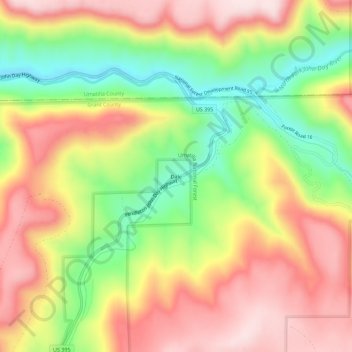
Navn: Topografisk kort Dale, højde, relief.
Sted: Dale, Grant County, Oregon, United States (44.96845 -118.96841 45.00845 -118.92841)
Gjennomsnittlig høyde: 1 035 m
Minste høyde: 834 m
Maksimal høyde: 1 214 m
Gi en donasjon
Andre topografiske kart
Klikk på et kart for å se dets topografi, dets høyde og dets relieff.
Canyon City
United States > Oregon > Grant County
The city is at an elevation of about 3,200 feet (980 m). Between Canyon City and Burns, to the south, Route 395 passes through parts of the Malheur National Forest. According to the United States Census Bureau, the town has a total area of 1.41 square miles (3.65 km2), all land.
Gjennomsnittlig høyde: 1 078 m
Gi en donasjon
Canyon City
United States > Oregon > Grant County > Canyon City
The city is at an elevation of about 3,200 feet (980 m). Between Canyon City and Burns, to the south, Route 395 passes through parts of the Malheur National Forest. According to the United States Census Bureau, the town has a total area of 1.41 square miles (3.65 km2), all land.
Gjennomsnittlig høyde: 1 078 m