
Takk for at du støtter denne siden ❤️
Gi en donasjon
Gi en donasjon
Topografisk kart Gascons
Klikk på kartet for å vise høyde.
Takk for at du støtter denne siden ❤️
Gi en donasjon
Gi en donasjon
Om dette kartet
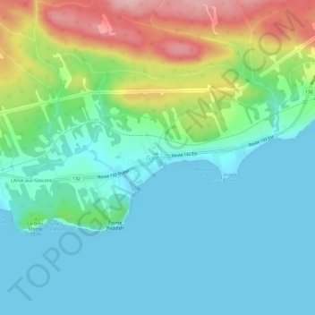
Navn: Topografisk kort Gascons, højde, relief.
Gjennomsnittlig høyde: 49 m
Minste høyde: -1 m
Maksimal høyde: 183 m
Takk for at du støtter denne siden ❤️
Gi en donasjon
Gi en donasjon
Andre topografiske kart
Klikk på et kart for å se dets topografi, dets høyde og dets relieff.
Takk for at du støtter denne siden ❤️
Gi en donasjon
Gi en donasjon
Chandler
Canada > Quebec > Le Rocher-Percé
The area was first settled in 1729, making it one of the oldest places on the Gaspé coast. It was known over time as Paboc, Pabo, Pabok, Pabeau, and Pas-bos. In 1815, the final spelling of Pabos was assigned in the Description topographique de la province du Bas Canada (Topographical Description of the…
Gjennomsnittlig høyde: 107 m