
Takk for at du støtter denne siden ❤️
Gi en donasjon
Gi en donasjon
Topografisk kart Madikeri
Klikk på kartet for å vise høyde.
Takk for at du støtter denne siden ❤️
Gi en donasjon
Gi en donasjon
Madikeri
Madikeri features a tropical highland climate as it has an elevation of 1,170 m (3,840 ft). Madikeri is located at 12°25′N 75°44′E / 12.42°N 75.73°E / 12.42; 75.73. Madikeri lies in the Western Ghats and is a popular hill station. The nearest cities are Hassan to the north, Mangaluru to the west, and Mysuru to the east. Kannur from Kerala is about 100 km (62 mi) away. The nearest international airport is Kannur International Airport which is 80 km (50 mi) away.
Takk for at du støtter denne siden ❤️
Gi en donasjon
Gi en donasjon
Om dette kartet
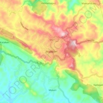
Navn: Topografisk kort Madikeri, højde, relief.
Sted: Madikeri, Madikeri taluku, Kodagu, Karnataka, 571201, India (12.38149 75.69875 12.46149 75.77875)
Gjennomsnittlig høyde: 1 054 m
Minste høyde: 880 m
Maksimal høyde: 1 283 m
Takk for at du støtter denne siden ❤️
Gi en donasjon
Gi en donasjon