
Gi en donasjon
Topografisk kart Chamoli
Klikk på kartet for å vise høyde.
Gi en donasjon
Om dette kartet
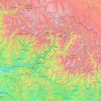
Navn: Topografisk kort Chamoli, højde, relief.
Sted: Chamoli, Chamoli District, Uttarakhand, India (29.80000 78.80000 31.20000 80.20000)
Gjennomsnittlig høyde: 3 472 m
Minste høyde: 564 m
Maksimal høyde: 7 630 m
Gi en donasjon
Andre topografiske kart
Klikk på et kart for å se dets topografi, dets høyde og dets relieff.
Bhagirathi River
The Bhilangna itself rises at the foot of the Khatling Glacier (elevation 3,717 m (12,195 ft)) approximately 50 km (31 mi) south of Gaumukh.
Gjennomsnittlig høyde: 2 256 m
Gi en donasjon
Gi en donasjon
Gangotri National Park
India > Uttarakhand > Bhatwari
The park harbors Western Himalayan subalpine conifer forests at lower elevations and Western Himalayan alpine shrub and meadows at higher elevations. Vegetation consist of chirpine deodar, fir, spruce, oak and rhododendrons.
Gjennomsnittlig høyde: 5 008 m
Gi en donasjon
Gi en donasjon
Gi en donasjon
Gi en donasjon
Haldwani
Haldwani is located at 29°13′N 79°31′E / 29.22°N 79.52°E / 29.22; 79.52, in the Nainital district on the right bank of the Gaula River. Geologically, Haldwani is settled on a piedmont grade (called Bhabhar) where the mountain rivers go underground to re-emerge in the Indo-Gangetic plain. The…
Gjennomsnittlig høyde: 523 m
Gi en donasjon
Ramganga Dam
India > Uttarakhand > Kotdwara
The dam is a 128 m (420 ft) tall and 630 m (2,067 ft) long earth and rock-fill embankment dam with 10,000,000 m3 (13,079,506 cu yd) of fill. The dam's spillway is controlled by five gates and has a maximum discharge of 8,467 m3/s (299,009 cu ft/s). To support the reservoir's elevation, there is a 72 m (236 ft)…
Gjennomsnittlig høyde: 389 m
Gi en donasjon
Gi en donasjon
Gi en donasjon
Gi en donasjon