
Gi en donasjon
Topografisk kart Callaway
Klikk på kartet for å vise høyde.
Gi en donasjon
Om dette kartet
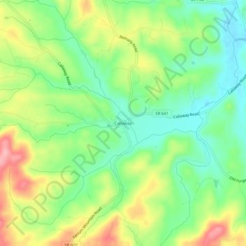
Navn: Topografisk kort Callaway, højde, relief.
Sted: Callaway, Franklin County, Virginia, 24067, United States (36.99153 -80.06948 37.03153 -80.02948)
Gjennomsnittlig høyde: 398 m
Minste høyde: 345 m
Maksimal høyde: 477 m
Gi en donasjon
Andre topografiske kart
Klikk på et kart for å se dets topografi, dets høyde og dets relieff.
Smith Mountain Lake
United States > Virginia > Franklin County > North Shore
Gjennomsnittlig høyde: 275 m
Gi en donasjon
Boones Mill
United States > Virginia > Franklin County
According to the United States Census Bureau, the town has a total area of 0.73 square miles (1.9 km2), all of it land. The town is in the valley of Maggodee Creek, a southeast-flowing tributary of the Blackwater River, part of the Roanoke River watershed. Murray Knob, elevation 2,286 feet (697 m), rises 2…
Gjennomsnittlig høyde: 390 m
Gi en donasjon