
Gi en donasjon
Topografisk kart Stonewall
Klikk på kartet for å vise høyde.
Gi en donasjon
Om dette kartet
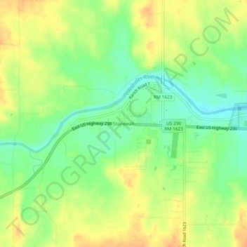
Navn: Topografisk kort Stonewall, højde, relief.
Sted: Stonewall, Gillespie County, Texas, 78671, United States (30.21593 -98.68462 30.25593 -98.64462)
Gjennomsnittlig høyde: 452 m
Minste høyde: 433 m
Maksimal høyde: 469 m
Gi en donasjon
Andre topografiske kart
Klikk på et kart for å se dets topografi, dets høyde og dets relieff.
Fredericksburg
United States > Texas > Gillespie County
Enchanted Rock is a geographical landmark 27 km (17 mi) north of Fredericksburg in Llano County. The rock is a huge, pink granite exfoliation dome that rises 425 ft (130 m) above the surrounding land, has a summit elevation of 1,825 ft (556 m) above sea level, and covers 640 acres (260 ha). Enchanted Rock…
Gjennomsnittlig høyde: 526 m
Gi en donasjon