
Gi en donasjon
Topografisk kart Josie
Klikk på kartet for å vise høyde.
Gi en donasjon
Om dette kartet
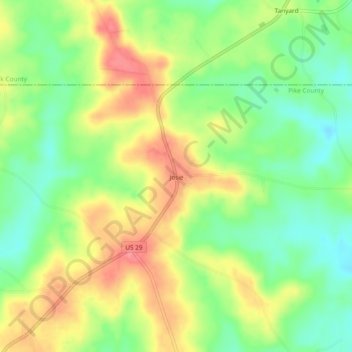
Navn: Topografisk kort Josie, højde, relief.
Sted: Josie, Pike County, Alabama, United States (31.84988 -85.73883 31.88988 -85.69883)
Gjennomsnittlig høyde: 149 m
Minste høyde: 111 m
Maksimal høyde: 192 m
Gi en donasjon
Andre topografiske kart
Klikk på et kart for å se dets topografi, dets høyde og dets relieff.
Troy
United States > Alabama > Pike County
Troy is located at 31°48′32″N 85°58′12″W / 31.80889°N 85.97000°W / 31.80889; -85.97000 (31.808768, −85.969951). It is in the East Gulf Coastal Plains region of Alabama. It is located along the Troy Cuesta ridge, which runs across the state from east to west and is the boundary that…
Gjennomsnittlig høyde: 131 m
Troy
United States > Alabama > Pike County
Troy is in the East Gulf Coastal Plains region of Alabama. It is located along the Troy Cuesta ridge, which runs across the state from east to west and is the boundary that separates the Chunnenuggee Hills and Southern Red Hills geographical boundaries. Elevations commonly reach 400 feet (120 m) in these hills…
Gjennomsnittlig høyde: 131 m
Gi en donasjon