
Gi en donasjon
Topografisk kart Big Creek Ranch
Klikk på kartet for å vise høyde.
Gi en donasjon
Om dette kartet
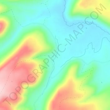
Navn: Topografisk kort Big Creek Ranch, højde, relief.
Sted: Big Creek Ranch, Mesa County, Colorado, United States (38.71501 -108.70538 38.73501 -108.68538)
Gjennomsnittlig høyde: 2 542 m
Minste høyde: 2 455 m
Maksimal høyde: 2 699 m
Gi en donasjon
Andre topografiske kart
Klikk på et kart for å se dets topografi, dets høyde og dets relieff.
Colorado River
United States > Colorado > Mesa County > Clifton
The entire eastern boundary of the Colorado River Basin runs along the North American Continental Divide and is defined largely by the Rocky Mountains and the Rio Grande Basin. The Wind River Range in Wyoming marks the northern extent of the basin, and is separated from the Colorado Rockies by the endorheic…
Gjennomsnittlig høyde: 1 417 m
Gi en donasjon
Fruita
United States > Colorado > Mesa County
The original town site was planned for 80 acres (32 ha) with a park in the middle. The first water reached the town from the Colorado River in 1907. By 1909, the town center was linked with electricity. In the 1930s, Fruita participated in several government projects, including the Grand Valley Resettlement…
Gjennomsnittlig høyde: 1 400 m
Colorado National Monument
United States > Colorado > Mesa County > Grand Junction
Gjennomsnittlig høyde: 1 809 m
Gi en donasjon
Fruita
United States > Colorado > Mesa County
The original town site was planned for 80 acres (32 ha) with a park in the middle. The first water reached the town from the Colorado River in 1907. By 1909, the town center was linked with electricity. In the 1930s, Fruita participated in several government projects, including the Grand Valley Resettlement…
Gjennomsnittlig høyde: 1 400 m
Colorado River
United States > Colorado > Mesa County
The entire eastern boundary of the Colorado River Basin runs along the North American Continental Divide and is defined largely by the Rocky Mountains and the Rio Grande Basin. The Wind River Range in Wyoming marks the northern extent of the basin, and is separated from the Colorado Rockies by the endorheic…
Gjennomsnittlig høyde: 1 417 m