
Gi en donasjon
Topografisk kart Windmere
Klikk på kartet for å vise høyde.
Gi en donasjon
Om dette kartet
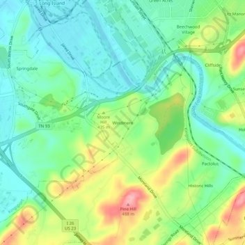
Navn: Topografisk kort Windmere, højde, relief.
Gjennomsnittlig høyde: 403 m
Minste høyde: 359 m
Maksimal høyde: 487 m
Gi en donasjon
Andre topografiske kart
Klikk på et kart for å se dets topografi, dets høyde og dets relieff.
Bristol
United States > Tennessee > Sullivan County
Like much of the rest of the state, Bristol has a humid subtropical climate (Köppen climate classification: Cfa), although with significantly cooler temperatures, especially in the summer, due to elevation; it is part of USDA hardiness zone 6b, with areas to the southwest falling in zone 7a. The normal…
Gjennomsnittlig høyde: 543 m
Gi en donasjon
Gi en donasjon
Gi en donasjon
Bristol
United States > Tennessee > Sullivan County
Like much of the rest of the state, Bristol has a humid subtropical climate (Köppen climate classification: Cfa), although with significantly cooler temperatures, especially in the summer, due to elevation; it is part of USDA hardiness zone 6b, with areas to the southwest falling in zone 7a. The normal…
Gjennomsnittlig høyde: 543 m