
Gi en donasjon
Topografisk kart Kirkcaldy
Klikk på kartet for å vise høyde.
Gi en donasjon
Kirkcaldy
Towards the end of the 16th century, a detailed assessment on the size of the townscape was carried out. The first estimate of the parish population in 1639 was between 3,000 and 3,200 and around 3,400 by 1691. At the beginning of the 18th century, the population declined. A census by Webster's Topographical Dictionary of Scotland in 1755, recorded an estimate of 2,296 in the parish. By the time of the first nationwide UK census in 1801, the population had risen to 3,248. The population of the burgh was recorded as 4,785 in the 1841 Census, and had risen to 34,079 by 1901. By the time of the 1951 Census, the figure stood at 49,050.
Gi en donasjon
Om dette kartet
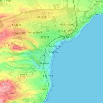
Navn: Topografisk kort Kirkcaldy, højde, relief.
Sted: Kirkcaldy, Fife, Scotland, KY1 1JA, United Kingdom (56.07102 -3.19823 56.15102 -3.11823)
Gjennomsnittlig høyde: 50 m
Minste høyde: -2 m
Maksimal høyde: 185 m
Gi en donasjon
Andre topografiske kart
Klikk på et kart for å se dets topografi, dets høyde og dets relieff.
Gi en donasjon
Gi en donasjon
Kellie Castle
United Kingdom > Scotland > Fife > Arncroach > Newton of Balcormo
Gjennomsnittlig høyde: 69 m
Gi en donasjon
Tentsmuir National Nature Reserve
United Kingdom > Scotland > Fife > Tayport
Gjennomsnittlig høyde: 4 m
Gi en donasjon
Gi en donasjon
Gi en donasjon
Inverkeithing
United Kingdom > Scotland > Fife
Topographically, Inverkeithing is situated on a raised terrace sloping down towards Inverkeithing Bay, which cuts in to the south of the town, separating it from the North Queensferry peninsula. Its medieval centre lay along High Street and Church Street, but the town has since expanded to encompass areas to…
Gjennomsnittlig høyde: 28 m
Gi en donasjon