
Takk for at du støtter denne siden ❤️
Gi en donasjon
Gi en donasjon
Topografisk kart Bhowali
Klikk på kartet for å vise høyde.
Takk for at du støtter denne siden ❤️
Gi en donasjon
Gi en donasjon
Bhowali
Bhowali (Kumaoni: Bhoāli) is a town and a municipal board in Nainital District in the state of Uttarakhand, India. It is situated at a distance of 11 km (6.8 mi) from the city of Nainital, the district headquarters; at an average elevation of 1,654 m (5,427 ft) from sea level. It is the seat of Bhowali tehsil, one of the eight subdivisions of Nainital district.
Takk for at du støtter denne siden ❤️
Gi en donasjon
Gi en donasjon
Om dette kartet
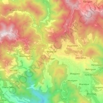
Navn: Topografisk kort Bhowali, højde, relief.
Sted: Bhowali, Nainital, Nainital District, Uttarakhand, India (29.34350 79.47884 29.42350 79.55884)
Gjennomsnittlig høyde: 1 672 m
Minste høyde: 866 m
Maksimal høyde: 2 449 m
Takk for at du støtter denne siden ❤️
Gi en donasjon
Gi en donasjon