
Gi en donasjon
Topografisk kart Boughton
Klikk på kartet for å vise høyde.
Gi en donasjon
Om dette kartet
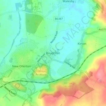
Navn: Topografisk kort Boughton, højde, relief.
Gjennomsnittlig høyde: 53 m
Minste høyde: 26 m
Maksimal høyde: 107 m
Gi en donasjon
Andre topografiske kart
Klikk på et kart for å se dets topografi, dets høyde og dets relieff.
Averham CP
United Kingdom > England > Nottinghamshire > Newark and Sherwood
Gjennomsnittlig høyde: 23 m
Southwell CP
United Kingdom > England > Nottinghamshire > Newark and Sherwood
Gjennomsnittlig høyde: 47 m
Sherwood Forest NNR
United Kingdom > England > Nottinghamshire > Newark and Sherwood > Ollerton > Edwinstowe CP
Gjennomsnittlig høyde: 71 m
Gi en donasjon
South Clifton
United Kingdom > England > Nottinghamshire > Newark and Sherwood
Gjennomsnittlig høyde: 8 m
Rolleston CP
United Kingdom > England > Nottinghamshire > Newark and Sherwood
Gjennomsnittlig høyde: 16 m
Gi en donasjon
Clipstone
United Kingdom > England > Nottinghamshire > Newark and Sherwood
Gjennomsnittlig høyde: 89 m
Rufford CP
United Kingdom > England > Nottinghamshire > Newark and Sherwood
Gjennomsnittlig høyde: 76 m
Balderton
United Kingdom > England > Nottinghamshire > Newark and Sherwood > Balderton
Gjennomsnittlig høyde: 20 m
Gi en donasjon
Egmanton CP
United Kingdom > England > Nottinghamshire > Newark and Sherwood
Gjennomsnittlig høyde: 50 m
Staythorpe CP
United Kingdom > England > Nottinghamshire > Newark and Sherwood
The land is very low-lying and level, varying little in elevation between 12–14 metres (39–46 ft) throughout.
Gjennomsnittlig høyde: 16 m
Eakring CP
United Kingdom > England > Nottinghamshire > Newark and Sherwood
Gjennomsnittlig høyde: 75 m
Gi en donasjon
East Stoke
United Kingdom > England > Nottinghamshire > Newark and Sherwood
Gjennomsnittlig høyde: 24 m
Kelham CP
United Kingdom > England > Nottinghamshire > Newark and Sherwood > Newark on Trent
Gjennomsnittlig høyde: 23 m
Caunton CP
United Kingdom > England > Nottinghamshire > Newark and Sherwood
Gjennomsnittlig høyde: 42 m
Gi en donasjon
Gonalston CP
United Kingdom > England > Nottinghamshire > Newark and Sherwood
Gjennomsnittlig høyde: 42 m
Ompton CP
United Kingdom > England > Nottinghamshire > Newark and Sherwood
Gjennomsnittlig høyde: 79 m
Kirton CP
United Kingdom > England > Nottinghamshire > Newark and Sherwood
Gjennomsnittlig høyde: 55 m
Gi en donasjon
Collingham CP
United Kingdom > England > Nottinghamshire > Newark and Sherwood
Gjennomsnittlig høyde: 15 m
Sherwood Forest National Nature Reserve
United Kingdom > England > Nottinghamshire > Newark and Sherwood > Ollerton
Gjennomsnittlig høyde: 71 m
Edingley CP
United Kingdom > England > Nottinghamshire > Newark and Sherwood
Gjennomsnittlig høyde: 63 m
Hockerton CP
United Kingdom > England > Nottinghamshire > Newark and Sherwood
Gjennomsnittlig høyde: 54 m
Gi en donasjon
North Muskham CP
United Kingdom > England > Nottinghamshire > Newark and Sherwood
Gjennomsnittlig høyde: 11 m
Newark
United Kingdom > England > Nottinghamshire > Newark and Sherwood > Newark on Trent
Gjennomsnittlig høyde: 17 m
Edwinstowe CP
United Kingdom > England > Nottinghamshire > Newark and Sherwood
Gjennomsnittlig høyde: 68 m
Wellow CP
United Kingdom > England > Nottinghamshire > Newark and Sherwood
Gjennomsnittlig høyde: 65 m
Gi en donasjon
Cromwell CP
United Kingdom > England > Nottinghamshire > Newark and Sherwood
Gjennomsnittlig høyde: 11 m
South Scarle CP
United Kingdom > England > Nottinghamshire > Newark and Sherwood
Gjennomsnittlig høyde: 11 m
Gunthorpe
United Kingdom > England > Nottinghamshire > Newark and Sherwood > Gunthorpe
Gjennomsnittlig høyde: 23 m
Vicar Water Country Park
United Kingdom > England > Nottinghamshire > Newark and Sherwood > Clipstone
Gjennomsnittlig høyde: 97 m
Gi en donasjon
Kirklington CP
United Kingdom > England > Nottinghamshire > Newark and Sherwood
Gjennomsnittlig høyde: 61 m
Lowdham CP
United Kingdom > England > Nottinghamshire > Newark and Sherwood
Gjennomsnittlig høyde: 36 m
Weston CP
United Kingdom > England > Nottinghamshire > Newark and Sherwood
Gjennomsnittlig høyde: 22 m
Gi en donasjon
Hoveringham
United Kingdom > England > Nottinghamshire > Newark and Sherwood > Hoveringham
Gjennomsnittlig høyde: 30 m
Spalford Warren
United Kingdom > England > Nottinghamshire > Newark and Sherwood > Spalford
Gjennomsnittlig høyde: 7 m
Epperstone CP
United Kingdom > England > Nottinghamshire > Newark and Sherwood
The report notes Epperstone's "very distinctive character... a combination of topography, buildings, trees and walls.... The constantly changing views make it an attractive space to move through." It also notes, "The approach to the village from the west is along a tunnel formed by overhanging trees, including…
Gjennomsnittlig høyde: 69 m
Blidworth CP
United Kingdom > England > Nottinghamshire > Newark and Sherwood
Gjennomsnittlig høyde: 107 m
Gi en donasjon
Bathley CP
United Kingdom > England > Nottinghamshire > Newark and Sherwood
Gjennomsnittlig høyde: 23 m
Caythorpe
United Kingdom > England > Nottinghamshire > Newark and Sherwood
Gjennomsnittlig høyde: 22 m
Bilsthorpe CP
United Kingdom > England > Nottinghamshire > Newark and Sherwood
Gjennomsnittlig høyde: 75 m
Kneesall CP
United Kingdom > England > Nottinghamshire > Newark and Sherwood
Gjennomsnittlig høyde: 71 m
Gi en donasjon
Carlton-on-Trent CP
United Kingdom > England > Nottinghamshire > Newark and Sherwood
Gjennomsnittlig høyde: 12 m
Sutton-on-Trent CP
United Kingdom > England > Nottinghamshire > Newark and Sherwood
Gjennomsnittlig høyde: 13 m
Gi en donasjon
Sherwood Forest NNR
United Kingdom > England > Nottinghamshire > Newark and Sherwood > Ollerton
Gjennomsnittlig høyde: 71 m
Ompton CP
United Kingdom > England > Nottinghamshire > Newark and Sherwood
Gjennomsnittlig høyde: 79 m
Hoveringham
United Kingdom > England > Nottinghamshire > Newark and Sherwood > Hoveringham
Gjennomsnittlig høyde: 30 m
Edingley CP
United Kingdom > England > Nottinghamshire > Newark and Sherwood
Gjennomsnittlig høyde: 63 m
Gi en donasjon
Egmanton CP
United Kingdom > England > Nottinghamshire > Newark and Sherwood
Gjennomsnittlig høyde: 50 m
Newark
United Kingdom > England > Nottinghamshire > Newark and Sherwood > Newark on Trent
Gjennomsnittlig høyde: 17 m