
Takk for at du støtter denne siden ❤️
Gi en donasjon
Gi en donasjon
Topografisk kart Georgetown
Klikk på kartet for å vise høyde.
Takk for at du støtter denne siden ❤️
Gi en donasjon
Gi en donasjon
Om dette kartet
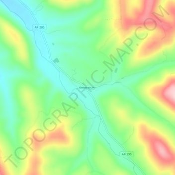
Navn: Topografisk kort Georgetown, højde, relief.
Sted: Georgetown, Madison County, Arkansas, United States (35.97563 -93.85131 36.01563 -93.81131)
Gjennomsnittlig høyde: 478 m
Minste høyde: 395 m
Maksimal høyde: 605 m
Takk for at du støtter denne siden ❤️
Gi en donasjon
Gi en donasjon
Andre topografiske kart
Klikk på et kart for å se dets topografi, dets høyde og dets relieff.
Saint Paul
United States > Arkansas > Madison County
St. Paul is located in the Upper Boston Mountains ecoregion. The ecoregion is generally higher and moister than the Lower Boston Mountains; elevations vary from 1,900 to 2,800 feet (580 to 850 m). Potential natural vegetation is oak–hickory forest. Characteristically, the forests of the Upper Boston…
Gjennomsnittlig høyde: 529 m
Takk for at du støtter denne siden ❤️
Gi en donasjon
Gi en donasjon