
Gi en donasjon
Topografisk kart Maricopa
Klikk på kartet for å vise høyde.
Gi en donasjon
Maricopa
The topography in Maricopa is flat, with several mountain ranges 10 to 20 miles away. The elevation of Maricopa is 1190 feet.
Gi en donasjon
Om dette kartet
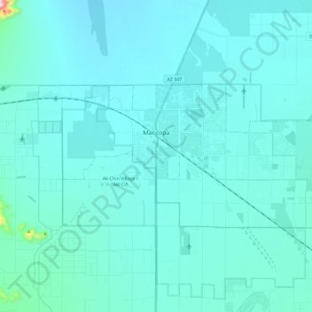
Navn: Topografisk kort Maricopa, højde, relief.
Sted: Maricopa, Pinal County, Arizona, United States (32.99913 -112.15078 33.08794 -111.92039)
Gjennomsnittlig høyde: 369 m
Minste høyde: 334 m
Maksimal høyde: 872 m
Gi en donasjon
Andre topografiske kart
Klikk på et kart for å se dets topografi, dets høyde og dets relieff.
Gi en donasjon
Oracle
United States > Arizona > Pinal County
Oracle has a cold semi-arid climate at an altitude of 4,500 feet (1,400 m). The record high temperature for Oracle was 109 °F (43 °C) recorded in July 1995. The record low temperature was 6 °F (−14 °C) recorded in December 1990. In January, the average high temperature is 56.7 °F (14 °C) with a low of…
Gjennomsnittlig høyde: 1 380 m
Gi en donasjon
Arizona City
United States > Arizona > Pinal County > Arizona City
Arizona City itself is mostly flat, lying in the Santa Cruz Valley in the center of three low mountain ranges; the Sawtooth Mountains to the south, the Picacho Mountains to the east, and the Casa Grande Mountains to the north. Picacho Peak, a prominent peak with a summit elevation of 3,374 feet (1,028 m), is…
Gjennomsnittlig høyde: 459 m
Gi en donasjon
Gi en donasjon
Gi en donasjon
Oracle
United States > Arizona > Pinal County
At an altitude of 4,500 feet (1,400 m), Oracle has a Mediterranean climate (Köppen Csa), somewhat similar to Prescott further northwestward. Unlike most climates of its type, only the early summer is dry, with monsoonal thunderstorms producing substantial rain in July and August. The winter season from…
Gjennomsnittlig høyde: 1 380 m
Heaton
United States > Arizona > Pinal County > Maricopa
Heaton is a populated place situated in Pinal County, Arizona, United States. Originally called Maricopa Station, it served as a stop on the railroad line, where passengers transferred to stagecoach. The post office at this location was simply named Maricopa. During a land boom in the late 1880s, it was…
Gjennomsnittlig høyde: 366 m