
Gi en donasjon
Topografisk kart Camelback Mountain
Klikk på kartet for å vise høyde.
Gi en donasjon
Camelback Mountain
Efforts to protect Camelback Mountain as a natural preserve began in the early 1910s. However, by the 1960s, nearly all of the area had been sold to private interests. Federal and state authorities attempted to stop development above the one thousand and six hundred feet level. They failed to halt development and in 1963 efforts to arrange a land exchange failed in the Arizona State legislature. In 1965, United States Senator Barry Goldwater took up the cause and helped to secure the higher elevations against development. The area became a Phoenix city park in 1968.
Gi en donasjon
Om dette kartet
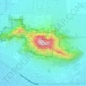
Navn: Topografisk kort Camelback Mountain, højde, relief.
Gjennomsnittlig høyde: 463 m
Minste høyde: 389 m
Maksimal høyde: 798 m
Gi en donasjon
Andre topografiske kart
Klikk på et kart for å se dets topografi, dets høyde og dets relieff.