
Gi en donasjon
Topografisk kart Bozeman
Klikk på kartet for å vise høyde.
Gi en donasjon
Bozeman
Bozeman is located at an elevation of 4,820 feet (1,470 m). The Bridger Mountains are to the north-northeast, the Tobacco Root Mountains to the west-south-west, the Big Belt Mountains and Horseshoe Hills to the northwest, the Hyalite Peaks of the northern Gallatin Range to the south and the Spanish Peaks of the northern Madison Range to the south-southwest. Bozeman is east of the continental divide, and Interstate 90 passes through the city. It is 84 miles (135 km) east of Butte, 125 miles (201 km) west of Billings, and 93 miles (150 km) north of Yellowstone National Park.
Gi en donasjon
Om dette kartet
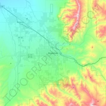
Navn: Topografisk kort Bozeman, højde, relief.
Sted: Bozeman, Gallatin County, Montana, 59715, United States (45.51943 -111.20405 45.83943 -110.88405)
Gjennomsnittlig høyde: 1 679 m
Minste høyde: 1 305 m
Maksimal høyde: 2 768 m
Gi en donasjon