
Gi en donasjon
Topografisk kart Cravenstown
Klikk på kartet for å vise høyde.
Gi en donasjon
Om dette kartet
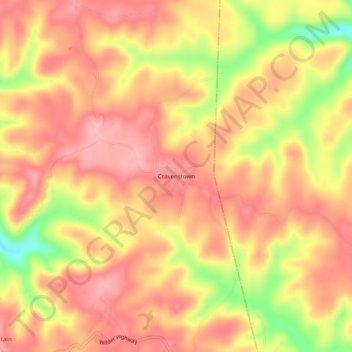
Navn: Topografisk kort Cravenstown, højde, relief.
Sted: Cravenstown, Overton County, Tennessee, 38589, United States (36.28507 -85.14774 36.32507 -85.10774)
Gjennomsnittlig høyde: 529 m
Minste høyde: 439 m
Maksimal høyde: 573 m
Gi en donasjon
Andre topografiske kart
Klikk på et kart for å se dets topografi, dets høyde og dets relieff.
Livingston
United States > Tennessee > Overton County
According to the United States Census Bureau, the town has a total area of 5.2 square miles (13 km2), of which 5.1 square miles (13 km2) is land and 0.04 square miles (0.10 km2) (0.77%) is water. Elevation in the town ranges from 1,027 ft (313 m) to 1700 ft (518.16 m)
Gjennomsnittlig høyde: 349 m